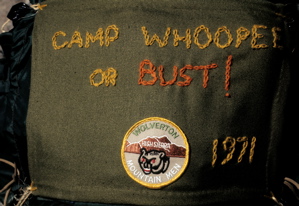
Whitset to Wolverton Trail
Log for a trail from Camp Whitsett to Camp Wolverton
Gary Parker and Jay Kandelin
Late Summer, 1971
This trail from Camp Whitsett BSA to Camp Wolverton BSA goes through Sequoia National Forest, Mineral King Game Refuge, and Sequoia National Park.
Camp Whitsett is located near Johnsondale, California and Camp Wolverton is near Giant Forest Village in Sequoia National Park, Callfornia. Some of the high points of the trip are Quaking Aspen Meadow in Sequoia National Forest, Farewell and Timber Gaps of Mineral King, and the Redwood Meadow Grove of giant sequoias in Sequoia National Park. The hikes starts in the White and Red Fir forests then moves into the Yellow Pine sections, then into the White Pine and Sugar Pine forests. The trip covers many different, beautiful sections of country. The total distance of the hike is about ninety miles.
The hike starts out at Camp Whitsett BSA which is about 4800 feet in elevation. We start on the Camp Nelson quad typographic map and leave Camp Whitsett heading east on the Carver Cattle Crossing. From there we take a logging road to where it hits the paved road to Quaking Aspen and then a series of old, abandoned logging roads in the direction of Windy Gap. About two and one half miles before Windy Gap we hit Nobe Young Creek where some campsites can be found. Then we continue on up the same logging road to the base of Windy Gap where we then take a cattle trail to the top. There are streams one quarter mile and one half mile before Windy Gap.
From the Gap we take the Summit Trail which is part of the California Hiking and Riding Trails System. One half of a mile past Windy Gap on the Summit Trail and is a stream suitable for camping. There is a large campsite one eighth mile past the stream. From there until Quaking Aspen Meadow Campgrounds there is no stream that could sustain a troop camping there. In fact, there is only one small stream past there; about one and a half miles before Quaking Aspen Meadow. This stream is good for drinking or filling canteens but not large enough for camping. At a small knoll off the trail four miles past Windy Gap, we see Mount Whitney, Farewell Gap and the Kaweah Ridges. One half mile before Quaking Aspen Meadow Campgrounds the trail stops again. This leaves us at the Quaker Meadow Camp where we proceed by dirt road to Quaking Aspen. At Quaking Aspen Meadow there is a public campground, telephone, and a Forest Service Guard Station.
From Quaking Aspen Meadow we proceed by paved road to the trailhead. Then we head on towards Gray Meadow, while passing through Junction Meadow, paralleling Clicks Creek, going through Clicks Creek Public Pasture and then on to Grey Meadow. At Grey Meadow there are two buildings which were built in 1917. One is a Forest Service Guard Station and the other a dwelling place for the cattle people who work in that area. At Grey Meadow there are two campsites with tables and stoves, water from a tap in the ranger's yard, and an outhouse. There is also a telephone at Grey Meadow for emergency use.
A mile past Grey Meadow is where our trail crosses the Little Kern River. In places the river is fifty feet wide but only six inches to one foot deep so fording it is no problem. There are excellent campsites here. From here on we start the climb on to Farewell Gap, although the actual Gap is twenty or so miles away. The next creek we hit is Table Meadow Creek which is usually dry late in the year and has no campsites.
Three quarters of a mile past the Little Kern crossing we switch to the Mineral King quad. From the Table Meadow Creek crossing to the Sheep Creek crossing we are temporarily on the Kern Peak quad. It is helpful to have this quad but not mandatory. A short three quarters of a mile past there is Lion Meadow and Creek. The creek runs year-round and there are campsites. It is best to get water from right under the barbed-wire fence so the grazing cattle have not contaminated it. To the east of the barbed-wire is private property, so keep off. An eighth of a mile past Lion Creek there is a trail junction with signs that say Mineral King, and point north. The trail it points to is not the trail we want, but we stay with that trail for another eighth of a mile until reaching an unmarked junction. The trail we are on will head northeast then turn east. This is the right fork. We want the left fork which heads Northwest and heads across the meadow. At this junction use a map and compass to find the correct fork. One mile past that junction is sheep creek which is a good lunch spot but has no campsites. Past there is Willow Creek, which has good water and campsites. Now onward past the chaparral to Tamarack Creek which has campsites and good water. Table Meadow, Lion, Sheep, Willow, and Tamarack Creeks all feed into the Little Kern River.
About a half mile past Tamarack Creek the trail follows a different route than that shown on the map. It goes over and parallels the Little Kern River for a mile and a half then cuts east for a quarter mile to the Rifle Creek public Campgrounds and Corrals. This is a very interesting place. It has three campsites with tables, chairs, stoves, food boxes, crossbars for tarps and other conveniences. It was built by the cattlemen of the area for their stays while herding cattle. It also has piped water and a head. The corrals are large enough to hold twenty or more horses. About one quarter mile past the Campgrounds is Rifle Creek.
Past Rifle Creek we come to Pistol Creek, where there is good, fast-flowing water, but no campsites. Then up the hill to Shotgun Creek where again the water is good but the are no flat spots for campsites. From an eighth mile before Shotgun Creek to a half mile after there is a section of reworked trail. The new section of trail continues in the northwest direction that the pieces before it and after it take.
Now we start the three-mile climb to Farewell Gap and Mineral King. We pass good water four times, but again there are no level spots for camping. The switchbacks to Farewell Gap are long, gentle and a pleasure to hike. Finally we hit the Gap and catch the first sight of Mineral King.
The trail down from Farewell Gap to the valley floor is a pleasant one. For all of the hike down we can look out at the Mineral King Basin. We pass creeks on the way down, but again no campsites are to be found. A mile before the bottom we hit a dirt road which we follow to the Timber Gap trailhead.
After spending the night at one of the Mineral King campgrounds we start early to climb Timber Gap. The sign at the trailhead says three miles but it is only one and a half to two miles in length. There are no reliable source of water on the way up. At the top of Timber Gap we get our first glimpse of Sequoia National Park and also enter it. Three miles below Timber Gap we reach Cliff Creek where there are excellent campsites.
Now onto Redwood Meadow which is only four miles from Cliff Creek. About a mile from Redwood Meadow we enter the Redwood Meadow Sequoia Grove. There are two old cabins at Redwood Meadow built on sequoia-wood foundations. They will last for ages. At Redwood Meadow there are campsites but no water so no camping. There is a telephone for emergency use.
Right at the end of the Redwood Meadow Campground there is a
slab of granite with words on it marking a fork in the trail. Disregard the directions on it as they are wrong. Take the left fork. But a new wrinkle, the trail to the left is a new reworked one and is different from the one on the map. It switchbacks down to Granite Creek instead of going straight down to it. But the new trail hits Granite Creek at the same point. There is good water and there are campsites at Granite Creek.
A quarter of a mile past Granite Creek is the bridge over the Middle Fork of the Kaweah River. There are campsites.
Now the trail turns west and in a mile we hit the junction of the trail going to Bearpaw Meadow. Take the right fork. As there are no signs use a map and compass to be sure. This trail goes through Little Bearpaw Meadow then reaches Bearpaw Meadow. There are a ranger station, campsites and telephone here.
From Bearpaw Meadow we take the High Sierra Trail. One mile from Bearpaw is Buck Creek which has good water and campsites along the creek north of the trail. About four miles past Buck Creek there is a trail junction where we leave the High Sierra Trail and that’s the trail that heads for Panther Gap and the Wolverton Corrals. One and three quarters miles past that junction is the turn off to Mehrten Meadow. Mehrten Meadow has water and large campsites. We keep heading toward Panther Gap. We now go over Panther Gap and down the Lakes Trail to the Wolverton trailhead and Camp Wolverton BSA, the terminus of our trip.